 |
|
Table of Contents
|
|
|||||||||||||||||||||||||||||||||

|
1. EDITORIAL During the passed three years, the Ministry of Environment and Housing of the Autonomous Government of Catalonia has led the INTERREG IIIC South project “DEDUCE” (Développement Durable des Zones Côtières Européennes, www.deduce.eu). An important element of the project was the application of indicators of sustainable development (ISD) for the coastal zone. This experience could be very useful for SPICOSA, and coordination between the two initiatives would certainly be very beneficial for establishing an ICZM evaluation system for the European coastal and maritime zones. The DEDUCE results will contribute towards the consolidation of the fundaments of the “European Monitoring and Data Network” for the coastal and maritime zones (EMODNET) in the framework of the European Maritime Policy (http://ec.europa.eu/maritimeaffairs). The DEDUCE Indicators Guidelines will help to complete the set of ISD, elaborate an indicator based sustainability evaluation model, create a coastal and maritime data infrastructure, and develop the information network. Over the coming years, EU funded projects related to ICZM should be very well coordinated in order to complete this work. At the same time, the results of the SPICOSA project will enable European coastal stakeholders to answer the crucial question of ‘what is required for sustainable development of coastal zones’. I would like to highlight two main areas where SPICOSA and DEDUCE follow-up activities can produce complementary outputs: (i) development of a sustainability evaluation system and (ii) integration of scale. The System Approach Framework (SAF) proposed and tested by the SPICOSA project could be a very important contribution towards developing tools for evaluating the sustainability of the coastal and maritime zones. To this end, close interaction between the SPICOSA managers and DEDUCE follow-up projects should be pursued. The practical utility and global application of the SAF can be ensured through the use of the ISD approach, on the condition that the ISD approach needs an input in order to increase its flexibility at all spatial scales. While the 18 SPICOSA study site applications will provide very useful information for the local scale, the main question ‘what is required for sustainable development of coastal and marine zones?’ needs a flexible and global answer. It will certainly not be possible to apply the same criteria or indicators for the evaluation of the sustainability of a coastal urban unit, of a coastal tourist unit, or of a coastal natural unit such as a delta. It is also clear that the sustainability criteria and indicators can be different for each sustainability goal - economic and social aspects cannot be treated the same way as biodiversity or climate change aspects. The SAF approach will make it possible to overcome the limits and barriers of the sectoral vision taking into account the interactions between the social, economic, territorial, and environmental aspects. In addition, the ISD approach can achieve this. Although the capacity of SPICOSA to build a tool for integrated analysis and sustainability evaluation is very strong, its potential would be enhanced greatly through cooperation with other initiatives such as DEDUCE follow-up projects in order to integrate better the indicators approach and to produce more useful and practical tools for coastal and maritime decision makers. The EC, the EU Member States and EU regions are in the process of consolidating their own sustainable coastal and maritime policies. In particular, they need an integrated and practical tool to organize well their information and to improve their decision making capacity. To this aim, it is necessary to coordinate the efforts for providing a compatible, synergic and complete package of ICZM tools. |
|

|
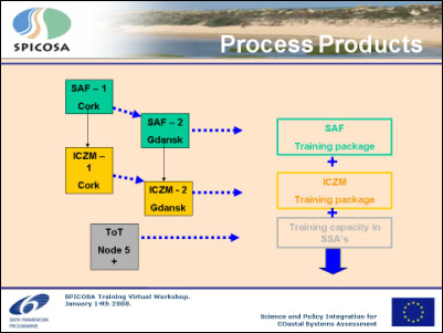
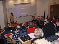
Cardiff University hosts virtual workshop “Identification of Training Needs” On January 14th, Cardiff University (UK) hosted the first virtual workshop to identify training needs of coastal professionals working in the SPICOSA project. Twenty-five representatives from SPICOSA Knowledge Transfer team (Node 5), Study Site Applications and sister projects ENCORA, CoastLearn and COREPOINT gathered for a two-hour virtual workshop. Participants were linked via telephone and to real-time PowerPoint presentations. A briefing package was distributed prior to the workshop so participants had clear information on the aims and content, as well as directions on how to join and contribute to the workshop. The package proved to be particularly useful and saved a great deal of time during the workshop.
Part of J. Hills Presentation on “What to Teach?” The virtual workshop specifically considered issues facing Study Site Applications (SSAs), training delivered by existing providers, approaches to assessing training needs, experiences from the COREPOINT and ENCORA projects, potential topics to be delivered by the SPICOSA project and modes of delivery. Participants were asked to complete two questionnaires immediately after the workshop. Some asked if they could discuss the questionnaires with the rest of their SSA team, thus stimulating debate beyond the workshop. Because of the workshop, a roadmap for developing and delivering training modules was agreed. This set out modules to be delivered, format of delivery, pilot sites and rollout and was used as the basis of the SPICOSA deliverable 13.1 “Identification of Training Needs”. The report is available on the SPICOSA website under the section Reports Online. For more information contact Jeanette Reis, Cardiff University (UK), e-mail: reisj@cardiff.ac.uk |
 |
|
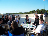
SSA mid–cluster meeting answered fundamental questions As with a lot of things in life (and in SPICOSA) defining ones existence is a challenging task. Things were no different for the SPICOSA Atlantic / Mid-Atlantic cluster. Were we truly Atlantic? Were we truly in the middle? Where is the middle? Moreover, as soon as you define and re-define your existence, exceptions to the rule pop up – for example, does the Danube SSA make us less Atlantic or less middle? ‘To be or not to be’ while it certainly was not the question, is an important lesson for working in the broader SPICOSA project. While we did not dwell on our ‘Atlantic-ness’ or ‘centre-ness’ for very long, this wayward discussion is leading to a point…stay with me. Definitions in SPICOSA are problematic and important. What is a ‘policy issue’? What is an ‘ecological dysfunction?’ How do they relate? What is a ‘virtual system’? Is SPICOSA an ICZM version of the Matrix? Defining these and many other SPICOSA terms is a critical step within the Systems Approach Framework (SAF). We found that SSAs had multiple meanings for these and other terms, in addition stakeholders were often confused or defined them differently. This all has relevance to rolling out the SAF – as it is the interpretations of these terms that set up upon the path of further modelling, data gathering and linking to stakeholders and policy. Choose the wrong path and you might end up in a different part of the forest!!
Mid-cluster meeting team One key objective of the mid-cluster meeting was to try and get past the difficult interpretations, for example a CATWOE, and dive into the work together. The most useful exercise was the sharing of knowledge around ICZM, different ways to attack the problems presented in the SAF, and ways to move forward together. For many of us it was the first time we had met or worked closely together, an important step in building this capacity and expertise. Overall, it was a very productive and enjoyable two days, with many SSAs expressing relief (or joy!) at being able to share their views and concerns. The SSA cluster meetings, no matter how they are defined, seem to be an engine of innovation and a source of help for interpreting and learning from the SPICOSA process. By Tavis Potts, Firth of Clyde SSA and Cluster Leader, e-mail: Tavis.Potts@sams.ac.uk |
 |
|
System Approach Framework moves ahead at study sites Between 4th and 8th of February, more than seventy SPICOSA partners joined and enjoyed the Carnival break workshop at the University of Algarve in Faro, Portugal. They came from all around coastal Europe and represented the 18 Study Sites Applications (SSAs) and Work Packages 4, 8, 11 and 12 responsible for the methodologies of the system approach framework definition, conceptual models, step formulation, communication, and training. Various workshops and pleasant sunny breaks promoted lively discussions, new encounters and better understanding among the partners representing a very broad spectrum of coastal sciences. The researchers presented and shared their Study Site Applications experiences, followed by discussions about the System formulation step, including the use and adaptation of the existing models for the SSAs. Information and experience was shared about local stakeholder involvement activities, problem definition, issue ranking, and planning of work. The event was a milestone and marked the progress made at the sites during the first year of the project. Before leaving, a training field visit to the Guadiana Estuary (the SSA-11 under the responsibility of the team of Tomasz Boski from CIMA UALG) was led by John Icely and Bruno Fragoso under the generous Southern sun.
After the workshop, hectic activity is anticipated for each Study Site team, not only for submitting their annual reports in time, but also for doing the necessary revisions needed for the next task, the Formulations Step. For further details contact Study Site Coordinator Josianne Stottrup, e-mail: jgs@difres.dk and/or the Guadiana Estuary SSA Coordinator Tomasz Boski, e-mail: tboski@ualg.pt. |
 |
||||||
|
List of upcoming events RESILIENCE 2008 - Resilience, Adaptation
and Transformation in Turbulent Times International Science
and Policy Conference ECOSYSTEM Services; Solution for problems
or a problem that needs solutions? 1st PoCoast Seminar on Coastal Research 2008 SUMMER SCHOOL ON ENVIRONMENTAL DYNAMICS LITTORAL 2008 - A CHANGING COAST: CHALLENGE
THE ENVIRONMENTAL POLICIES |
 |
|
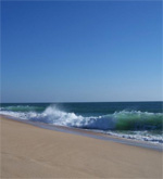
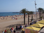
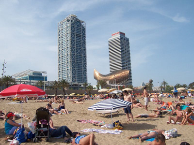
The Project will test and improve its methodology, the System Approach Framework (SAF) at various sites in a limited, real-time configuration. We have chosen eighteen Study Site Applications (SSAs) all over Europe for this purpose. In each issue of this SPICOSA Newsletter, we will introduce some study sites. Barcelona Coast, Spain The metropolitan area of Barcelona, situated on the northwestern Mediterranean coast, has a population of over two million and has been a major economic centre since the end of the 18th century. Barcelona is the capital of Catalonia, an autonomous region of Spain and is home to one of Europe’s principle Mediterranean ports for both cargo and cruise ships, and the second largest airport in the country. The city is situated on the plateau between the coast and the Collserola mountain range and between the two rivers of the Llobregat, to the southwest, and the Besòs to the north east. The 30 km of linear coastline is broken by various coastal infrastructures such as ports, and protective barriers. Typical Mediterranean hydrological conditions exist such as almost negligible tides and low energy wave activity. The most persistent current direction is to the south-west with an average velocity of between 5 and 10 cm per second. The oligotrophic marine waters are naturally enriched by the deep Mediterranean waters through winter mixing and sporadically by freshwater land runoff. The coast receives average discharges from the Besòs and Llobregat of 5 and 20 m³ per second respectively although this is subject to extreme variation during storms – rising as high as 2000 m³ per second. Both rivers pass through urban, industrial and agricultural zones covering river basins of 1000 km² (Besòs) and 5000 km² (Llobregat). During high precipitation events, the city’s storm collectors are unable to cope with the large volume of water and untreated urban water run-off is released directly into the coastal waters. The coastline is almost completely artificial, mostly occupied by the industrial and leisure ports, the rest of which has been regenerated as municipal beaches, totaling around 5 km. Despite hard coastal infrastructures such as groins and breakwaters, the beaches suffer erosion and require regular regeneration following storms. The beaches were constructed prior to the 1992 Summer Olympic Games on land previously inhabited by industrial buildings. Pollution released by these industries for many decades has resulted in the accumulation of contaminated bottom sediment.
Barcelona beach Most impacts on the coastal zone are a result of typical urban activities such as waste-water treatment and soil-sealing due to urbanisation. Marine related impacts stem from pollution from the ports, dredging and dumping. Additionally, agricultural and industrial pollution is released into the river basins, affecting the quality of the coastal water and local fisheries, and resulting in the loss of some key commercial species. This impact has also been exacerbated by spatial conflicts between the expanding commercial port and fishing guilds. The beach is popular for both the local residents of Barcelona and the large number of tourists that visit the city. The aesthetic quality of the water is often affected during storms resulting from untreated waste water and the river plumes that form near the river Besòs. Occasionally bathing is prohibited if bacteria levels rise too high or during the presence of harmful algal blooms or jellyfish, thus reducing the recreational appeal of the coastal zone, affecting the revenues of local businesses. By Ben Tomlinson, Barcelona Coast (Spain) SSA Team, e-mail: <Tomlinson@icm.csic.es> |
 |
|
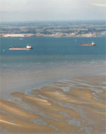
The study area is located at the south-western part of the Netherlands and the north-western part of Belgium. It is formed by three major rivers: the Scheldt, the Rhine and Meuse. The Scheldt-Delta SPICOSA case study is an E(cological) S(ocial) and E(conomic) assessment of the major Water Framework Directive (WFD) objective of achieving good ecological status concerning phytoplankton in the Scheldt river basin including the coastal zone. The focus is on social and economic analysis of apportionment of nitrogen objectives in the river basin, and feasibility and costs of nitrate reduction measures concerning agriculture, households and natural areas. This issue emerged as one of two priorities during a meeting with stakeholders engaged in the Belgian-Dutch Delta area. In a transboundary context, the WFD allows for exemptions in cases where a certain Member State cannot resolve the reasons for not achieving the environmental objectives because they lay outside the competence and jurisdiction of the Member State. There is also the political debate concerning what should be subjected to a systems analysis, where measures should be taken and for what price and affecting whom. The phasing of the implementation of measures and the setting of less stringent objectives are part of an assessment of disproportionality. Disproportional costs in comparison to the benefits are based on affordability arguments and distributional consequences. The need for case studies is identified at the EU level in the WFD Common Implementation Strategy process. The contribution of the Scheldt river to the annual budget of nitrogen in the adjacent coastal zone is significant. Common understanding of the differences in assessment methodologies and common approaches will enhance solutions to meet the WFD objectives.
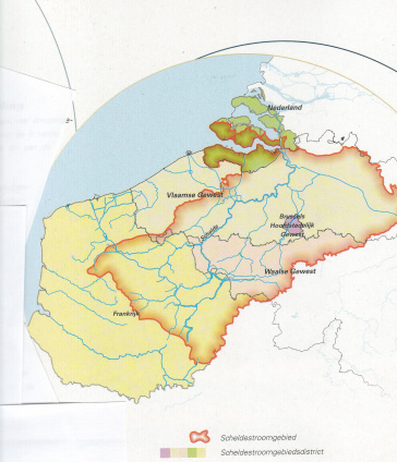
The Transboundary Scheldt river basin with coastal waters, transitional waters and rivers requiring cost-effective measures to reach WFD good ecological quality objectives Ecological indicators to be used are identical to those formulated within the WFD Scheldt river basin management plan. The selected key indicators are Chlorophyll–a and Phaeocystis. Economic indicators will be not only costs of measures related to WFD compliance, but might also be the added value in integration with Birds and Habitat Directive and Flood Directive. Social indicators might relate to regional prevalence, governance, and political choices in willingness to pay. Political aspects to be considered using the indicators will contribute to key questions of spread of costs in time, affordability, and disproportionality. The overarching management objective is to comply with the regulations set by the WFD in such a way that the Ecological Quality Objective for the receiving water is reached. The desired reduction of the nitrogen concentrations in the North Sea can be obtained by emission reductions of point and diffuse sources or by increasing (more wetlands) the self-cleaning capacity (especially the denitrification) of water systems in the drainage area of the Scheldt River. The major point sources of nitrogen in the Scheldt are waste water treatment plants; the major diffuse source is agriculture. The effect of an increasing self-cleaning capacity by denitrification will be calculated by adding different “virtual” areas with different characteristics and water balances to the conceptual model, not real existing areas in the Scheldt river basin.
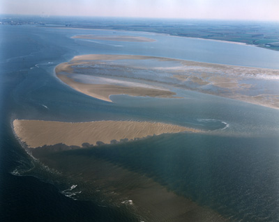
Hooge Platen A full PCraster based hydrological model of the complete Scheldt catchment will be made, to assess the different point and non-point sources of the N-load. This will involve quantification of the contributions of agriculture and domestic sewage treatment works. Most of the data are available in a wide range of reports, and where these are unavailable fairly sound educated guesses from nearby catchments will be made. The ESE system will cover further the ecological, economic and social conceptual models. For future scenarios, it will build on and integrate existing information. The so-called G and W+ climate scenarios developed by the Royal Dutch Meteorological Institute of the Netherlands and the so-called IPPC SRES (special reports on emission scenarios) A1, A2, B1, B2 socio-economic scenarios offer a broad range, but may give all the information required. Other sources, like particular scenario studies for WFD implementation (VMM, BE) are more specific but are especially limited or very close to business as usual scenarios. Other information (e.g. from the Eururalis project) will also be evaluated. The final decision on which scenarios will be used during the modelling and analysis phase will be made in close communication with the main stakeholders. This will be discussed during the next stakeholders meeting. By Jannette van Buuren, Scheldt-Delta (Netherlands) SSA Team, e-mail: <jannette.vanbuuren@deltares.nl> |
 |
| COLOPHON SPICOSA NEWS is a newsletter produced by the SPICOSA consortium for professionals dealing in one way or another with coastal science, planning, and management. It is to be published every four months. The next issue is due in June 2008. This electronic newsletter may be forwarded freely to others working in the ICZM field. If you would like to receive the SPICOSA Newsletter directly, please subscribe. If you no longer would like to receive the SPICOSA Newsletter, please unsubscribe. News-items for publication can be send to
|
An integrated project under the
|