SPICOSA´s central objective of developing the Systems Approach Framework (SAF) centres on methodologies for simulating the function of coastal zone systems. The simulation software EXTEND applied at SPICOSA Study Sites makes it possible to show how complex Coastal Zone systems react to a wide range of changes in the use and management of these systems and, in return, how changes in the natural systems influence economic and social sectors. Currently, the SPICOSA Study Sites are kicking off the formulation step using EXTEND for making models. EXTEND Demo EXTEND News
EXTEND Software
SPICOSA definition of system simulation In other words, the goal of the SAF is to develop the capacity to simulate, in an operational manner, changes in status and in value of coastal-zone systems induced by human influences and vice versa. In our first attempt, we will focus on providing decision-makers with the best-possible information on ‘what-if scenarios” for the use in implementing the Sustainable Development in coastal zones. For example, these scenarios will simulate the costs and benefits mutually occurring between the costs of sustaining the total value of natural systems and monetary benefit of their increasing use. Both natural and anthropogenic systems are strongly time dependent, inherently so, because their inputs (e.g. sunlight, meteorology, socio-economic needs) are all strongly time-dependent and often importantly spatially dependent. For decision-making processes, the first-order simulations will have to do with changes in cost or public disapproval as a function of time; and among the important spatial questions will be the distributions of these costs over the policy domain. These simulations and their interpretations will be converted to a language and format convenient for end-users and packaged in a way that will facilitate future users through its self-evolving and accumulative mechanisms.
Systems Approach Framework
These tricks will serve us to the degree that we want an integrated response and that we can accept some degree of error. These concessions are offset by the possibility that we can continue refine the exercise to the limit of our understanding and information base. With modern advances in commercially available software, we are much less limited by computation than were the researchers of the sixties when system simulations were first attempted. Likewise, the availability today of large supportive data sets and greater knowledge allows us to tackle problems that would have been impossible a generation ago.
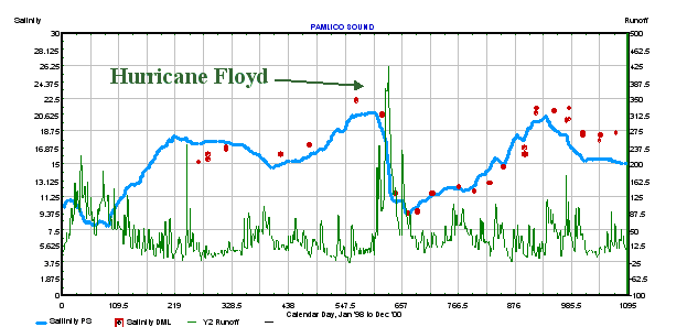
Lagoon Salinity. A simulation of the salinity
in the Pamlico Sound (North Carolina, USA) was run for the years
1998 through 2000 with the only input being the observed Atlantic
salinities, and the local meteorology. The series was run without
adjustments after its initial calibration for mixing and friction
in the inlet. Blue line is the simulated salinity values, the red
dots are observed salinities, and he green line the observed runoff.
The large runoff peak was due to the flooding caused by Hurricane
Floyd. Full agreement would not be expected because of approximations
in the input data. Close agreement over the 4-yr interval indicates
that the dynamics are correctly formulated (otherwise the solution
would not be stable). This model is constructed using the non-linear
thermohaline method for estuarine exchange, see Hopkins, T.S., 2001.
Thermohaline feedback loops and natural capital. Scientia Marina,
65 (Suppl.2): 233-258 |

